Navigation Clinic Recap 2020
Being a total map nerd, and having learned map and compass navigational skills back in college, I, Elena, had been dreaming of doing a Navigation Clinic since we started Rocky Mountain Sportswomen. At our first event, a happy hour meet and greet at Steamboat Whiskey Company, I met a woman named Andrea. During our conversation, she mentioned she worked with maps and map making as a living. We held a survey to see what type of events our attendees were interested in, and she mentioned topographic maps and navigation! I lit up, and knew this was something I wanted to execute.
A year and a half later, we made it come to life! We decided a hike to the top of Hahn’s Peak would be the perfect place to work our legs, and have a great 360 degree view from the top. Hahn’s Peak is a Steamboat Springs classic, that every local needs to check off the list. Located about an hour north of Steamboat in Clark, Colorado, the peak reaches 10,774 feet in elevation. At the top, you can see Steamboat Lake, Pearl Lake and many other surrounding peaks throughout Routt County.
Creating the lesson plan with Andrea really made me tap into my skills learned from my college degree of Wilderness Leadership and Experiential Education at Brevard College in North Carolina. I even reached out to a couple of my old professors for advice. Navigation was a major subject in our program, and I knew I wanted to share that knowledge with the ladies of Rocky Mountain Sportswomen.
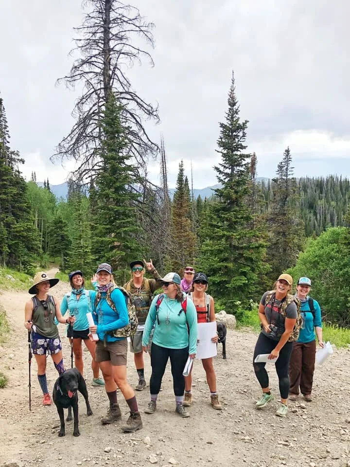
On the day of the clinic, a few of us met up at the Walmart parking lot to carpool to the trail head where we would meet a couple other participants. At this point a few of the ladies that had signed up for the clinic ended up not being able to make it, so we had a few extra copies of maps and compasses. Jaime and I rode together, because we always have way too much to talk about between our personal lives, and business. As we approached the trail head, we noticed a little car parked off to the side, just a few hundred feet from the actual parking area. The road was pretty rough, so we understood the reasoning. As we passed the car, we saw a young woman walking up the road to the trail head, and I said to Jaime, “I wonder if she’s in our navigation clinic? I wonder if she wants to be?!” Without hesitation, Jaime was already rolling down my passenger window. “Hey! Do you want to join us and a bunch of other ladies on a navigation clinic to the top of Hahn’s Peak? We have an extra map and compass for you!” Also without hesitation, and a big smile, she responded, “sure!” And jumped in the back seat next to Jaime’s beloved shepherd, Chevy. It was a moment we’ll never forget. The straggler we ended up picking up, was a nice young woman named Colleen who had just moved to the area back in October. With the Covid outbreak, and working pretty far outside of Steamboat, she mentioned how she hadn’t really had the chance to meet a lot of people and was in search of some sort of women’s group! Turns out, we found her instead. Colleen ended up being such a fun addition to our group, and we were so happy to help her discover new friends who are ready to adventure with her!

Colleen doing her woodland dance, stoked to have stumbled upon some awesome ladies.
We gathered in the parking lot where we talked and got to know each other as other participants arrived. With a total of 10 women, we circled up with a little introduction to the day and who we are as Rocky Mountain Sportswomen. Each event has presented us with new faces, and we love it. We passed out the copies of the topographic maps of Hahn’s Peak and the surrounding area, that were printed and donated to us by a friend, Ken Burns from Advanced Copier Solutions in Steamboat Springs. Right on time, we began our hike up the steep trail to the top of Hahn’s Peak.
Hiking was a great way for us to break the ice and have some fun conversations, all while enjoying the beautiful wildflowers and views on the way up. Andrea and I were playing it by ear on where we would stop and do a lesson on topographic map reading. Turns out, we just kept hiking. Right when we reached the edge of treeline, however, we were interrupted by some intimidating dark clouds, and it had begun to sprinkle. We decided to not take the risk of being struck by lightning on top of the bare peak, and huddled under the pines to wait it out. This was the perfect opportunity to do our map lesson. Kelly, just so happened to have a tarp in her pack, so we whipped it out, and tied it to a few trees for some of us to hide under to prevent getting wet. It was perfect.


Cindy waiting out the rain with her sweet poochie.
We began our map lesson by going over some of the basics of reading a topographic map, which isn’t typically easy at first! Most of our participants signed up because they were eager to learn a little bit more about maps and how to use them in case your phone ever dies in the wilderness and you can’t read your location. We went over contour lines, the longitude and latitude grid, the meaning of the USGS maps, and more. We will be sharing a separate blog of everything we learned including links to some of our favorite online resources soon, so stay tuned!

A couple of different copies of the Hahn’s Peak area that were given to all of our participants.
Throughout the lesson, we would pause and quiz the girls on a few things we just learned, just to make sure everyone was learning! We gave away a few subscriptions to ONX Maps, one of our favorite hunting tools. ONX is a map app that is created by and for hunters. It allows you to save maps offline so that you can always see your location. You can view the map in both satellite and topographic views, track your mileage, save way points, and much more! If you haven’t already, check out ONX. It has definitely become one of our favorite tools for e-scouting, hiking, fishing, and hunting all together.


Right when our little map lesson was wrapped up, we took a snack break, which included our favorite, Altitude Snacks from Steamboat Springs. Then, just in time, the sun began to shine on us again, and we continued our hike to the top of the peak. Things seem to work out like that for us sometimes.


There’s a point in the hike where the dirt trail turns into a complete shale trail. Nothing but rock. We pressed on, and the views at the end towards the top were breathtaking, making the trek well worth it. We all trickled to the peak, and made an effort to sign the book inside the shack located at the top. A lot of our girls had never hiked Hahn’s Peak before, including both Jaime and myself! Now we could officially check it off, and we were so glad we decided on this hike.


Before reaching the top, Andrea and I had decided it would be cool to do our compass reading lesson at the very top of the peak, so that we could teach the participants how to take bearings from various peaks that are visible. However, dark clouds rolled in again and we even saw a strike of lightning off in the distance. We quickly finished up our photo taking, and began our descent.

Right below the peak, however, was a nice flat landing where we decided would be a great spot to teach about compasses, and still have a great view, but without the lightning risk. We had another snack break and began our lesson.
Navigating with compasses is a lost art, but still is an important one. Personally, having always been a map nerd, I always know where I am and generally which direction is which. But that’s not instinctual for a lot of people. I think tapping into these skills can not only help you figure out where you are, but can also build your connection with the great outdoors, and where you stand in it. Having that knowledge makes me feel more comfortable and confident about being in the wilderness. Compass reading is simple, but can be complicated to wrap your head around without practicing with it a few times. This navigation clinic could have easily been in a classroom setting, but with my experiential education background, nothing sticks with you better than a solid experience that you won’t forget, as well as applying it in the field.

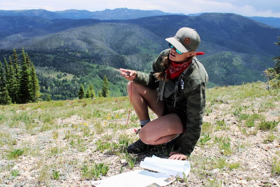
We went over how to take a bearing from a certain point, and how to operate the compass properly. This included accounting for declination, which is unique to where you are in the world. We had the ladies take bearings from different points and how it lines up with your properly oriented map. Again, stay tuned for our Navigation Resources page to learn more! Though overwhelming, the participants confirmed that they had learned a ton, and now understand the mystery behind map and compass reading. We were stoked. We also took the opportunity to give away a couple more ONX subscriptions!


After our fun lesson and another Altitude Snacks break, we continued our descent down the mountain, and back to the trail head. Our fun conversations and friendship building continued down the trail, and quickly we ended up back to our vehicles. Cindy, one of our participants, brought us some delicious Kombucha to share afterwards. Mortal Kombucha, her son’s company from Boulder, Colorado, donated a case for us to check out, and we fell in love! It was a nice treat at the end of the fun hike. We still had one more ONX card to giveaway, along with an official USGS map of the Hahn’s Peak area. Since you can see the peak from the parking lot, we had our girls line up and take the bearing from the lot to the peak. It was a great way to refresh their brains after our compass lesson closer to the top.

Being new friends, and not wanting the fun to end, we all decided to meet up at Hahn’s Peak Roadhouse, a token restaurant that is a must when recreating in the Clark area. Here we enjoyed a couple beers, burgers, and fun conversations! This navigation clinic was a huge success, and we are so excited that everyone walked away with some new knowledge and a compass! We hope to do another one in the future, and will be sure to let you know when our Navigation Resource page is live!
-Elena Reynolds
Founder of Rocky Mountain Sportswomen
Special thanks to Advanced Copier Solutions for printing off our maps and to Altitude Snacks, OnX Maps and Mortal Kombucha for donating your products to enjoy on our hike!

